Urban Planning Experiments NYC 2026: a Data-driven Snapshot
Neutral and data-driven coverage of Urban planning experiments in NYC 2026, detailing innovative pilots, comprehensive timelines, and significant impacts.
New York is again at a crossroads where city planning, technology, and daily life intersect. As of 2026, Urban planning experiments NYC 2026 are shaping how streets, neighborhoods, and public spaces function in the near term, with a sustained push toward measurable outcomes. The city’s open streets expansion, neighborhood rezoning efforts, and data-driven policy pilots are being designed to test what urban spaces can deliver for residents, workers, and local businesses alike. In early 2026, city officials, researchers, and community groups have been tracking a growing set of experiments that blend tactical urbanism with formal planning processes, aiming to quantify benefits such as safety, economic vitality, and inclusive access. This coverage highlights the current landscape, why these experiments matter, and what to expect next as the city continues to test and refine its approach to urban mobility, housing, and public space governance. Urban planning experiments NYC 2026 are unfolding in real time, with data dashboards, public consultations, and a dense calendar of pilot projects that could reshape how New Yorkers experience their streets for years to come. (nyc.gov)
What Happened
Open Streets 2026 rollout and pilots
In late 2025 and into 2026, the New York City Department of Transportation expanded its Open Streets framework to more neighborhoods and integrated newer, sensor-enhanced pilots designed to measure street usage, safety, and economic activity in near real time. The city also formalized the 2026 Open Streets cycle with stricter timelines and a broader applicant pool. For the first time, the 2026 lineup included proposals that could transition to Limited Local Access or Full Closure statuses, and the application deadline extended to January 31, 2025 for most sites, with a separate deadline of January 31, 2026 for programs tied to the upcoming 2026–2027 school year. This progression reflects a deliberate push to scale what began as a tactical urbanism program into a more data-supported municipal tool. The DOT’s announcements and Streets Plan updates indicate a deliberate mix of pedestrian-only spaces, bicycle prioritization, and street-side programming to test how open spatial configurations influence activity and commerce. (nyc.gov)
Neighborhood rezoning momentum across the five boroughs
Across 2025 and into 2026, several high-profile rezoning initiatives have entered the public and legislative arenas, signaling a broader testing ground for how zoning can support mobility, housing, and local economies. In Southeast Queens, Jamaica’s neighborhood plan—launched through a community-led process and advanced by the Council—aims to deliver nearly 12,000 new homes, including roughly 4,200 permanently affordable units, alongside jobs and community investments, marking one of the city’s more ambitious neighborhood-scale transformations in recent years. The Jamaica plan’s trajectory illustrates how large-scale rezoning is being coupled with inclusionary housing and infrastructure opportunities to create long-term economic and social feedback loops. These actions are part of a wider pattern that includes Midtown South’s mixed-use plan and broader efforts to protect existing industries while expanding housing supply. (council.nyc.gov)
In Midtown South, leadership from the City Council and nearby agencies advanced a robust zoning package designed to unlock thousands of new homes, with a particular emphasis on affordable units. The plan, publicly released and discussed in 2025, projects approximately 9,535 new homes, including up to 2,842 permanently affordable homes, alongside public realm improvements and transportation investments such as a proposed car-free busway corridor and enhanced protections for the Garment District. The package reflects a strategy of using rezoning as a lever to align housing, jobs, and transit access in one of the city’s densest and most transit-oriented districts. (council.nyc.gov)
In another strand of policy, Fulton Park in Brooklyn has entered into formal environmental and planning review processes, signaling a reimagining of a municipal park and adjacent development area through a framework that could involve an Urban Development Action Area designation and zoning map amendments. The environmental notice and scoping process, including public sessions scheduled for 2026, highlight how the city uses formal planning steps to vet urban redevelopment in parallel with market-driven investment. While the Fulton Park action is still evolving, it embodies the property-and-park interface at the heart of contemporary urban planning experiments NYC 2026. (dec.ny.gov)
Tech-enabled planning and civic data initiatives
A growing layer of Urban planning experiments NYC 2026 involves the integration of data science, sensors, and participatory design to inform decision-making. The Pratt Institute’s Urban Futures Hackathon series—designed to blend design thinking with data-science workflows—has continued to influence how designers and public servants co-create city futures. A recent iteration positioned NYC as a living lab for place-based scenario testing, with a public exhibition planned for 2026. This kind of academic-practitioner collaboration helps translate complex datasets into accessible planning narratives and testable proposals for city agencies and communities. (pratt.edu)
In parallel, street-level pilots and analog-to-digital measurement efforts have become a core component of the urban planning toolkit. Street Lab’s 2025 recap underscores a city-wide emphasis on proving concepts through practical traffic-modulation experiments, temporary infrastructure, and community partnerships. The initiative documented how street design choices—such as temporary curb extensions, planting configurations, and programmable signage—affect pedestrian flows, business activity, and perceived safety. While not every pilot becomes permanent, the learnings feed into the city’s longer-range Streets Plan framework and inform how pilots scale or wind down. (streetlab.org)
NYC’s Streets Plan update for 2025 also codified how open spaces and street design should be evaluated, incorporating performance metrics, safety indicators, and economic outcomes. The plan highlighted a broader ambition to use pilot programs as learning engines for policy and design decisions, with a recognized need for transparent data sharing and community engagement. The document notes expanded open-street programs, the Dining Out NYC pilot, and other street-level innovations that together reveal a pattern of iterative experimentation rather than a single, monumental reform. (nyc.gov)
Why It Matters
Economic and community impact of street-level experiments

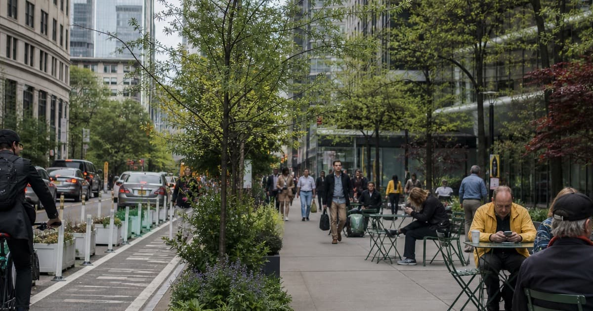
Photo by Florian Wehde on Unsplash
Open Streets initiatives, which broaden pedestrian-first street spaces and expand time-limited car-free zones, are not just about aesthetics; they are economic experiments with measurable effects. Independent reporting and city dashboards point to tangible outcomes: thousands of jobs linked to street activation, improvements in storefront occupancy, and shifts in local retail dynamics. One influential analysis found that open streets locations with five-year continuity (2020–2024) generated significant employment opportunities and contributed to lower storefront vacancy rates in neighborhoods that embraced pedestrianized space. The evidence base—though still evolving—suggests that well-planned open streets can function as community infrastructure that supports small businesses and neighborhood vitality while maintaining mobility for residents. This evidence is repeatedly echoed in open-streets data updates and post-implementation assessments. (nyc.streetsblog.org)
The economic logic behind open streets also intersects with housing-and-venue strategies that cities increasingly embrace. As neighborhoods gain more dynamic street environments, adjacent commercial and cultural activity tends to cluster, creating a feedback loop that can bolster local employment and storefront viability. At the same time, these experiments must address equity considerations—ensuring that improvements in one corridor do not come at the expense of others and that access to amenities remains broadly distributed across diverse communities. The Jamaica and Midtown South rezoning efforts illustrate how housing and economic development policies are being paired with street-level strategies to maximize broader neighborhood impacts. (council.nyc.gov)
Housing, inclusion, and neighborhood-scale experimentation
The 2024–2025 neighborhood rezoning activity provides a concrete lens through which to view Urban planning experiments NYC 2026. Jamaica’s plan is framed as the city’s largest neighborhood rezoning in over two decades, projecting tens of thousands of new homes over a multi-decade horizon and putting a spotlight on inclusionary housing as a central design principle. The plan’s structure—combining density increases with protections for affordability and targeted investments—illustrates how planners are testing the balance between growth and equity in a way that is meant to be scalable to other neighborhoods across the city. Midtown South’s plan similarly emphasizes housing production alongside amenities and transit-linked improvements, showing how rezoning can be deployed to align multiple city-building outcomes in high-density corridors. (council.nyc.gov)
Neighborhood-scale experimentation also interacts with city-level ambition by testing governance approaches that can be scaled if successful. Public sessions, environmental reviews, and legislative actions around rezoning demonstrate a procedural backbone for evaluating community impact, risk, and opportunity. These processes are crucial because they formalize the transition from pilot projects to potentially permanent changes in land use, street design, and public investment. The Fulton Park process, for example, highlights how permitting, environmental review, and adjustments to zoning and public investment decisions can run in parallel with private development activity, giving planners a structured way to monitor and adjust outcomes over time. (dec.ny.gov)
Data, transparency, and citizen engagement
A central thread in Urban planning experiments NYC 2026 is the push for greater transparency and better use of data in planning decisions. The Streets Plan updates, combined with open-streets data and public dashboards, aim to provide residents with accessible evidence about how street changes affect mobility, safety, and local economies. This emphasis on data-enabled governance aligns with broader city strategies to share planning context publicly, invite feedback, and adapt based on measurable results. The 2025–2026 period has included new data-sharing tools, performance metrics, and public-facing dashboards intended to demystify how pilots translate into policy. Researchers and civic tech advocates emphasize that, while dashboards are valuable, their value increases when they are complemented by rigorous impact studies and ongoing community dialogue. (nyc.gov)
What's Next
Upcoming milestones and public participation
Looking ahead, a steady cadence of milestones is expected in 2026 as neighborhoods move from pilot concepts to more formalized plans and potential approvals. The Fulton Park rezoning process will continue through environmental scoping, public hearings, and council review, with scheduled sessions announced for early 2026. Public participation is central to these steps, with opportunities for residents to weigh in on design choices, traffic patterns, and the balance between new development and preservation of neighborhood character. The city’s legislative workflow—driven by Int 0235-2026 and related processes—signals that governance mechanisms are actively shaping the pace and form of Open Streets and rezoning initiatives. Public notices and calendars for scoping sessions are typically posted through city channels, and community boards often summarize how these proposals could affect local services, schools, and small businesses. (dec.ny.gov)
Monitoring, adaptation, and long-range planning
As pilots advance, the city plans to rely on sensors, performance metrics, and qualitative feedback to refine designs or scale successful interventions. For example, sensor-powered street pilots intend to deliver real-time data on pedestrian walk times, vehicle volumes, and commercial activity, enabling rapid adjustments to signal timing, curb usage, and street furniture. Studies and practitioner reports emphasize that the real value of Urban planning experiments NYC 2026 lies in iterative learning—measuring what works, documenting unintended consequences, and adjusting policies accordingly. This approach is reinforced by the Streets Plan’s emphasis on data-informed decision-making and by academic collaborations that push the boundaries of how urban form and technology intersect in practice. (nyc.streetsblog.org)
What to watch in 2026 and beyond
- Open Streets expansion and performance: The 2026 Open Streets cycle, with schools joining in Summer 2026, will be a key indicator of how the city scales pedestrian-centric street use and what economic effects emerge in diverse neighborhoods. Observers will track not only safety and mobility metrics but also business activity and seasonal demand. (nyc.gov)
- Rezoning outcomes and housing delivery: Jamaica, Midtown South, and Fulton Park will continue to test the capacity of rezoning to deliver housing and jobs while preserving affordability and neighborhood character. The pace and public reception of these plans will shape how the city deploys similar strategies in other districts. (council.nyc.gov)
- Data-driven planning tools: The integration of dashboards, sensor networks, and participatory design workshops will be watched closely to determine how data transparency translates into improved policy outcomes and more effective citizen engagement. Academic and civic-tech partners will likely publish findings that influence the next generation of planning tools. (pratt.edu)
In sum, the ongoing Urban planning experiments NYC 2026 reflect a city that is testing how street space, housing policy, and public infrastructure can be aligned to deliver measurable benefits. The combination of open-street pilots, neighborhood-scale rezonings, and data-driven governance creates a multi-layered laboratory for urban experimentation. As the year unfolds, analysts, residents, and policymakers will be watching not just the outcomes in isolated corridors but the extent to which these experiments inform scalable, inclusive, and resilient city-building strategies for the next decade. (nyc.gov)
Closing
For residents and local stakeholders, the 2026 cycle of urban planning experiments offers a clear reminder: city planning now operates with a stronger emphasis on testing, measurement, and public accountability. The best way to stay informed is to follow official updates from the New York City Department of Transportation, the City Planning Commission, and the Office of the Mayor, while also engaging with community boards and local press coverage that translates technical planning documents into accessible, timely insights. Manhattan Monday will continue to track these developments, providing updates on pilot outcomes, policy shifts, and opportunities to participate in the conversation around Urban planning experiments NYC 2026.

Photo by Harrison Mitchell on Unsplash